

Are snow-producing clouds safe to fly through?
- Dr. Scott Dennstaedt

- Jan 7, 2022
- 6 min read
When talking to instrument rated pilots, it's not uncommon to hear a few of them boast that it's perfectly safe to fly in the clouds when those clouds are producing snow. Yes, snow falling from the base of a cloud can indicate that the clouds are dominated by ice crystals especially when the temperature at the surface is below -15°C. In other words, snow can sometimes lessen the icing threat; however, that is not the case most of the time. In fact, in a study by S. Green who examined cases of icing accidents and incidents (an incident may be a stall, high sink rate, hard landing, loss of control, etc.) it was determined freezing precipitation (e.g., freezing rain, freezing drizzle) is present in 33% of the total events in the data and snow was reaching the surface in 32% of the events as shown below.

Once a weather system is deep enough to produce precipitation, knowing how precipitation affects the icing potential is an interesting problem to study. To the dismay of pilots, there's not always a clear way to know. We know that freezing rain and freezing drizzle represent a nasty icing environment...even the presence of ice pellets at the surface can indicate there's a likely chance to experience supercooled large drop (SLD) icing aloft. Freezing rain is a ground-hugging event so exposure is usually down near the surface during a departure from or approach to an airport. Freezing drizzle, on the other hand, does occur at greater depths and arguably represents a much more dangerous icing scenario. But what if the precipitation type is strictly snow?
First, flying in the snow below the clouds or in between layers is rarely an airframe icing hazard. Beware, it can be very disorienting. Even so, it may build up on air inlets creating an induction icing concern, so using alternate air may be necessary. If snow begins to accrete on the airframe, treat it like any other icing situation; exit those conditions as soon as practicable and use any ice protection equipment to remove the accretion of ice.
Even when there's no icing concern, rain falling through a cloud will tend to scour out liquid drops both small and large through a collision and coalescence process. But it's true that snow falling through a cloud will tend to also purge some of the supercooled liquid water in it. As a snowflake tumbles through the cloud it bumps into liquid cloud droplets on its way up or down within the cloud and that supercooled cloud droplet will rime onto the snowflake, thus, removing that droplet from the cloud which lessens the threat. Moreover, in some colder snow-producing scenarios, the cloud becomes saturated with respect to ice (solid water) and at that point it causes the ice crystals to grow at the expense of supercooled liquid water. In other words, liquid drops begin to readily evaporate and that vapor deposits directly onto the growing ice crystals to produce bigger snowflakes, thus, depleting the cloud of liquid water.
In order to get a snow-producing cloud, you need a fairly cold cloud top temperature or a layer or two of clouds higher up that are dumping ice crystals (called seeding) into a warmer (but subfreezing) layer below. Certainly when the tops are colder than -15°C, ice nuclei begin to activate and the cloud turns from all-liquid to a mixed phase cloud consisting of both ice crystals and supercooled liquid water. When the cloud top temperature is warmer than -15°C you should anticipate that the cloud is dominated by liquid water. Of course, you should expect to see supercooled liquid water in these warm-topped clouds when the static air temperature in the cloud is expected to be below 0°C. Let's take a look at a snow-producing example using the EZWxBrief progressive web app.

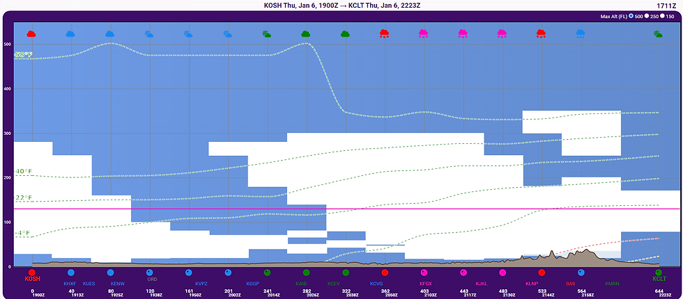
Consider an early afternoon departure from Oshkosh, Wisconsin to Charlotte, North Carolina with a route overflying Chicago. It's early January and there's a weather system brewing in the Tennessee Valley just east of the Appalachian Mountains. From the EZMap view above that depicts the weather layer using the EZForecast for 22Z, there is a large area of low IFR conditions (magenta) all predict snow reaching the surface. This is also evident in the EZRoute Profile shown below for a 19Z departure. The departure airport is on the left and destination on the right. As you approach the Tennessee Valley area, high clouds build in first and then about midway on the flight you can expect to fly into visible moisture. In this example, the cruise altitude is 13,000 feet MSL as indicated by the magenta horizontal line. Temperature at this altitude along the latter half of the route will be warmer than -20°C in clouds producing snow.
Before we get too deep into the icing discussion, let's take a look at the big weather picture. First, the prog chart valid at 18Z, depicts this area of low pressure developing along the spine of the southern Appalachian Mountains. This area of low pressure is expected to deepen and move to the east-northeast with time (not shown). The precipitation forecast valid at 18Z depicts a likely area of snow (dark blue) over a good portion of the latter half of the route (red dashed line) and is similar to the area presented on the EZMap above.

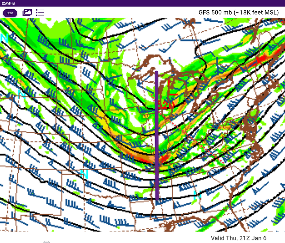
Looking below at the 500 mb forecast (~18,000 feet MSL) valid at 21Z from the GFS model EZImagery, there is a trough that is moving eastward through the Midwest with the route (shown as a red dashed line) on the downwind side of the trough axis (shown by the solid purple line). This places the route in a prime position signifying upper level support associated with the areas of low pressure shown on the prog chart above.
The 700 mb forecast (~10,000 feet MSL) also valid at 21Z shows a rather large area of negative omega (shown by the solid red contour) covering much of the Tennessee Valley and Mid-Atlantic regions. This is indicative of upward motion of air around the developing area of low pressure on the windward side of the Appalachian Mountains.

A quick look at the icing severity depiction on the EZRoute Profile, it's apparent that some regions on the windward side of the Appalachian Mountains could experience some moderate to heavy airframe ice.

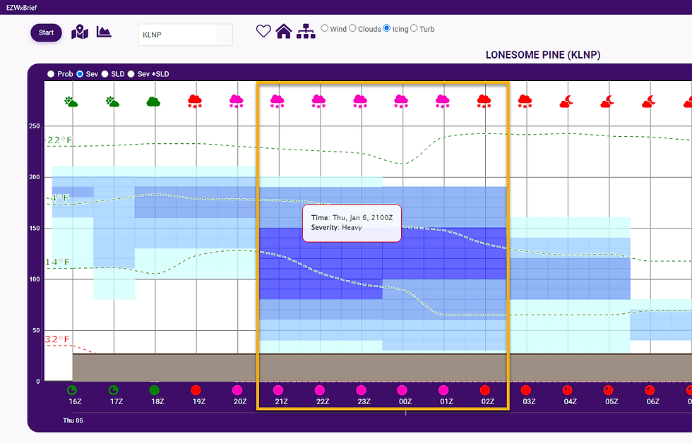
If we drill down and further and evaluate the icing depiction at some point along the route (white arrow above), let's look at Lonesome Pine Airport (KLNP) in Wise, Virginia. The icing meteogram found on the EZAirport page shows heavy icing potential from 21Z through 02Z in this region. What is remarkable though is that the precipitation type expected to reach the surface is snow.
We can also look at the forecast sounding nearby this airport to gain a bit more insight into the temperature profile aloft. Below is a 7 hour forecast valid at 22Z and is located within just a few miles of the route of flight and nearby KLNP. First thing to notice is that the entire temperature profile is below 0°C. The temperature progressively gets colder with height. That's key to producing snow such that it makes it all the way to the surface. The tops in this forecast sounding are likely around 30,000 feet MSL.
Now for the not-so-obvious details. The atmosphere in the forecast sounding below is saturated from the surface through the tops at 30,000 feet. This is fairly consistent with the clouds depiction from the EZRoute Profile above. With very cold cloud top temperature approaching -50°C, this allows ice crystals to build and the cloud to produce copious amount of snow. Next, the temperature profile is saturated with respect to liquid water (supersaturated with respect to solid water (e.g. ice crystals) from the surface through about 20,000 feet designated by the red dashed line below. Above that altitude and up to the tops, the atmosphere is saturated with respect to ice crystals and subsaturated with respect to liquid water. This is the region where you'd expect little or no liquid water given the colder temperatures and subsaturated conditions.

The real key driver for heavy icing is the region of moist absolute instability from about 14,000 through 20,000 feet. This is likely a region of mixed phase where both ice crystals and supercooled liquid water both exist. However, in the presence of upward motion as seen on the 700 mb forecast omega field, this can help really squeeze out a lot of moisture between 10,000 and 20,000 feet. This tends to agree with the moderate to heavy regions of icing on the EZRoute Profile above. The moral of the story is that snow alone is not an accurate way to determine if there is icing potential in the clouds producing that snow. In some cases you can get heavy icing. There were a few PIREPs near this area reporting moderate ice above 10,000 feet. The PIREP below is from an MD-11 that reported moderate icing at 16,000 feet.

Most pilots are weatherwise, but some are otherwise™
Dr. Scott Dennstaedt
Weather Systems Engineer
Founder, EZWxBrief™
CFI & former NWS meteorologist


Comments