top of page

Search


EZTip - EZDeparture Advisor for icing and turbulence
You may have noticed a bunch of gray squares on the EZWxBrief EZDeparture Advisor™ when planning a route and wonder what those gray squares mean...
Dr. Scott Dennstaedt
Sep 29, 20252 min read


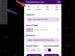
EZTip - Deleting a route in EZWxBrief
Learn how to delete a route in the EZWxBrief progressive web app.
Dr. Scott Dennstaedt
Sep 15, 20252 min read


EZTip - EZWxBrief calibrated forecasts for icing
The icing forecast in EZWxBrief is a calibrated probability that ranges from 0% through 85% as shown in the legend below. Icing forecasts in EZWxBrief rendered in the meteogram and in the Route Profile view carry a lead time as far out as 20 hours in the future. So what is a calibrated probability and how should it be interpreted?
Dr. Scott Dennstaedt
Sep 8, 20252 min read


EZTip - Color coding in METARs and TAFs
Learn how EZWxBrief provides color-coding for METARs and TAFs.
Dr. Scott Dennstaedt
Feb 17, 20252 min read


EZTip: Practical use of the EZWxBrief meteogram
Generically, a meteogram is a time-series graph that shows the actual or expected weather at a particular location (usually an airport)...
Dr. Scott Dennstaedt
Jan 9, 20253 min read


EZTip - SIGMET layer on the EZWxBrief map
The EZWxBrief progressive app provides the capability to see the latest surface observations and EZForecast for most airports in the U.S....
Dr. Scott Dennstaedt
Sep 10, 20242 min read


EZTip - Area Forecast Discussions in EZWxBrief
The Airport Wx view in EZWxBrief provides access to the most recent area forecast discussion (AFD) for each airport located in the...
Dr. Scott Dennstaedt
Sep 5, 20244 min read


EZTip - Deleting a route in EZWxBrief
Once an active route is created in EZWxBrief , it will persist from one session to the next. This is to facilitate using EZWxBrief on...
Dr. Scott Dennstaedt
Sep 3, 20242 min read


EZTip - About time in EZWxBrief
It’s essential to know the valid time of any weather guidance you may use. There are two choices in the EZWxBrief progressive web app for...
Dr. Scott Dennstaedt
Aug 25, 20242 min read


bottom of page
