Are you baffled by the discussion?
- Dr. Scott Dennstaedt

- Apr 1, 2022
- 4 min read
Updated: Feb 10, 2023
Since I introduced the area forecast discussions (AFDs) to pilots a couple decades ago, this has become a common resource for pilots to review when making operational decisions as it relates to weather. These are issued by the forecasters at the 123 National Weather Service local Weather Forecast Offices (WFOs) throughout the United States and its territories. The colored areas below are called county warning areas (CWAs) and that represents the WFO boundaries. The same forecasters at these offices issue TAFs for airports that are in their CWA.

In EZWxBrief, you can access these AFDs through the EZAirport page by choosing the menu icon on the right then select Discussion as shown below. Based on the airport chosen (in this case KLGA), EZWxBrief will compare that airport to its location in the CWAs above and provide the appropriate discussion for that airport.

Each AFD has two primary parts of interest to pilots. The first consists of a synoptic overview and a review of the forecast weather over the next few days. The second part is the AVIATION section where the forecaster will discuss any pertinent information about the TAFs they issue for their CWA. This second part is generally written in such a way that it is easily understood by any pilot or other stakeholder in aviation (e.g., air traffic controller). How much information they put into this section often depends on the specific WFO and the individual meteorologist. In some cases, a forecaster can pack a lot of information into that AVIATION discussion and some will offer very few details.
Unlike the AVIATION section, the primary discussion in the AFD is meant to be a forecaster-to-forecaster discussion and can be quite technical at times as you can see below. This is an excerpt from the AFD issued by the NWS forecast office in New York City. Let's take a look at the weather charts they are referring to in the discussion below.
.LONG TERM /MONDAY THROUGH THURSDAY/...
Mid level ridging will take place across the local area Monday into Monday evening. Mid level transitions to a zonal pattern thereafter through Tuesday and then more SW Tuesday night through midweek with shortwave approaching. Mid level ridging shown in forecast models thereafter through Thursday.
The first thing the forecaster says is "mid-level ridging will take place across the area on Monday into Monday evening." First, by mid-level they are referring to the 500 mb level which is roughly the half-way point in the atmosphere. That is, at the surface the sea level pressure is roughly 1,000 mb and the top of the atmosphere is 0 mb...so half of the mass of the atmosphere is above 500 mb and half of the mass is below. For reference, 500 mb level is roughly 18,000 feet MSL.
As you can see below from the 500 mb GFS model forecast valid at 11Z on Monday, there is a ridge expected to move through the lower Great Lakes and Ohio Valley (ridge axis shown by the blue line). This is a fairly week ridge, but from a forecasting perspective in New York, the heights (black contours) will be rising as that ridge moves east through the day on Monday. A ridge represents an area of warmer air and is dominated by subsidence or sinking air that generally produces fair weather or improving conditions.

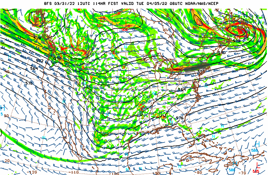
Next, the discussion says, "mid-level transitions to a zonal pattern thereafter through Tuesday." A zonal pattern is one that is primarily west to east flow with no meridional (north-south) component to the pattern. The ridge that moved through during the day on Monday, flattened out to bring in that zonal flow. This is apparent on the 500 mb forecast below valid at 06Z on Tuesday with the gray arrow showing the winds flowing west to east. In a zonal pattern, the heights generally remain the same over time. A zonal pattern usually represents a benign flow and is common during the warm season in the southern two-thirds of the U.S.

Next the discussions continues, "...and then more SW Tuesday night through midweek with shortwave approaching." A shortwave is a trough of lower heights which represents colder air aloft moving in. The 500 mb forecast from the GFS model valid at 12Z on Wednesday shows that positive-tilted short wave trough (trough axis shown by the red line) moving into the New York region with upper-level winds (gray arrow) from the southwest.

Last, the discussion says, "Mid-level ridging shown in forecast models
thereafter through Thursday." Once again, a ridge (axis marked by the red line) is expected to dominate the New York City area from Wednesday into Thursday as shown below.

This discussion is simply a brief explanation of how the weather pattern is expected to transition over the period from Monday through Thursday (long range forecast). Expect generally fair weather when the area is dominated by a ridge and disturbed weather when it is dominated by a [shortwave] trough.
Most pilots are weatherwise, but some are otherwise™
Dr. Scott Dennstaedt
Weather Systems Engineer
Founder, EZWxBrief™
CFI & former NWS meteorologist


Comments